Monday, June 22, 2009

East Bay creeks map - historic & contemporary

An excellent East Bay creeks map can be downloaded from here:

http://www.museumca.org/creeks/MapOak.html


Published By: The Oakland Museum of California, 1993, Rev. 1995, Rev 2000.


You used to be able to buy nicely-printed folded copies at the museum store. At least the map is still available as a pdf download.


Also that page has links to webpages with detail sections of a number of creeks.


(I gave them the idea, many years ago, because I didn't have the resources to do it myself. And they followed through! Thank you!)

1936 Map of (main) East Bay Creeks

Friday, June 19, 2009

History - Elk

"Look across Tomales Bay to see Millerton Point on the opposite shore, the source of food and supplies for Inverness for many years.  After the great Earthquake and Fire of '06, dozens of San Franciscans built small summer homes in Inverness to insure a place to live in the event another disaster would wipe out their city digs.  By 1913 the growing resort population drove out the Wapiti or Roosevelt elk, native to the Point Reyes Peninsula.  Old newspaper accounts record that the herd was so large a swimming gang of animals 50 feet in breadth could be seen crossing the Bay day and night for three days.  Rangers in the

National Seashore hope someday to re-establish a herd of elk."


Margot Patterson Doss: Paths of Gold (SF: Chronicle Bks, 1974,  p.156)

Wednesday, June 17, 2009

Ideas for Responding to Sea Level Rise

http://www.risingtidescompetition.com/risingtides/Home.html


An International Competition for Ideas Responding to Sea Level Rise in San Francisco Bay and Beyond - 


The San Francisco Bay Conservation and Development Commission (BCDC) is hosting an open international design competition for ideas responding to sea level rise in San Francisco Bay and beyond.

--------------

Suggestion: Buy up the creek estuaries, remove buildings - restore the wetlands! Bring back the fish, crab, clams, etc that once were abundant!

History of Oakland's Creeks 5

Oakland's Forgotten Creeks

by Dave Hope, 1947


(Last in a series of five articles.)

The Creeks Today


Never let it be inferred that Oakland's forgotten creeks gave up their identities without a struggle. 


Man could dry up their sources and shunt them underground. He could encase them in sled pipes, bury them under slabs of concrete, cross them with streets, hide their banks with buildings. But he didn't find it an easy job.


They hibernated in quiet through long summer months, waiting patiently for the days when skies opened up and poured rain water into their channels. Then they exacted heavy toll for the indignities they had suffered. 


Forgotten creeks were suddenly and painfully remembered as flood waters inundated business. and residential areas. No extensive memory is required to recall the Berkeley store that found a geyser erupting from its basement, with merchandise floating out the front door and bobbing down the street.


ANNUAL VISITATION 


Businessmen and home owners of the Grand Lake district, among others, came to regard the flooding of their properties as an annual visitation. Even today storm waters inundate Cypress Street and some other sections during every heavy 

rain. 


This happens in a city which has a gentle slope to the bay, and "soil of so porous a quality as to afford sufficient drainage and entirely obviate the necessity for artificial 

drains and sewers." 


That was the somewhat unduly optimistic opinion of Mayor Horace W. Carpentier, stormy petrel of Oakland's incorporation, as he became the city's first executive in 1854. His claim seems to have held up for some 10 years, during which 

creeks were regarded merely as defiles that had to be bridged for new streets.


But in 1866 the residents of Oakland were beginning to realize they needed some other attention. The city's first sewer was constructed that year, from Fourth Street to 

the waterfront, on Broadway. 


BOARD APPOINTED 


Three years later a Board of Engineers was appointed to study the Oakland drainage problem and investigate systems in cities all over the world. Their recommendations led to construction of a sewer on Webster Street, from 12th Street to the waterfront, in 1871.


One year later Mayor Spaulding was refuting his predecessor by describing the ravages of Temescal Creek which ran wild to submerse everything from 21st Street to the Bay. He said that construction of San Pablo Road and Telegraph

Road, both of which have since been dignified as avenues, had diverted

the natural flow of Oakland's northern creeks.


Plans were drawn for a big project, on which work was conducted in 1873.  Extending 9924 feet in length,  constructed  partially of wood, partially of brick, it ran along 22nd Street, from Lake Merritt to the Bay, and cost the city $166,000.

The actual cost figures are drowned in red ink. Two contractors defaulted on the job before it finally was completed in 1876.


DRAINAGE PROBLEM


Through succeeding years Oakland struggled with drainage problems, always too little and too late with each segment as the need mounted continuously with  the 

growth of the city. Bond issues were passed from time to time until, in 1925, Ihe city adopted a pay as you go policy. Work proceeded haphazardly after that. 


Then in 1936 came the WPA and Oakland moved swiftly to take advantage   of  Federal   assistance. Grand Avenue floods got first attention with a $355,000 project. A 35th Avenue job cost $36,000, a Mandana Boulevard project $57,000. Pipe more than 30 years old was replaced along High Street, from 45th Ave-

nue to East 14th Street, at a cost of $17,000.  


Some 20 projects, costing a total of more than $1,250,000, of which the city paid only supervision and engineering charges, were included in the WPA program. 


Mayor Carpentier, long since removed from concern over all such mundane things, wouid undoubtedly have been aghast at such an expenditure, but it was only a beginning. The biggest part of the job was and still is yet to be done. 


HALTED BY WAR


War halted the WPA program, but not the need for drainage. Late in 1944 the City Council authorized City Engineer Walter N. Frickstad to outline a post-war program. He presented them with a $6,000,000 plan.  


If, included 48 projects, all but nine of them to carry storm waters. Each has its base in an outlet, which once was the mouth of an Oakland creek. They follow the courses of creeks, with adjustments and laterals and connections to meet

complicalions man introduced into nature's drainage system.


In May, 1945, the citizens of Oakland voted a $5,361,000 bond issue to pay for the program. In spite of material shortages and a scarcity of engineers, it is already well advanced.


A portion of Ihe Stonehurst system, which will eventually cover construction of large sections of San Leandro Creek, has been completed to allow for huge industrial

development near San Leandro Street and 100th Avenue.


OTHER PROJECTS PLANNED


An Elmhurst section, running from Blaine to E Streets, is under construction. Some maintenance work has been done along the old Glen Echo Creek in the upper 

Broadway district. Contract has been let for a Grand Avenue job.


Advanced planning indicates that work on the sites of such creeks as 141h Avenue, Park Boulevard, Temescal, and Arroyo Veijo will follow in the near future.


Factors which nature never intended, which the Spanish Dons couldn't conceive, which Mayor Carpentier would have considered fantastic, are involved. The new system must separate storm waters from sewers, divert them from the $25,000,000 interceptor to be built for handling the area's sewage. Its out-

ets must pass beneath the East Shore Freeway's band of concrete which will skirt the water's edge. It must be correlated to highway and sewage and residential and industrial development of tremendous scope.


Oakland's old creeks may be forgotten—but Oakland's drainage system has become one of the city's most crucial problems. 

History of Oakland's Creeks 4

OAKLAND'S FORGOTTEN CREEKS

by Dave Hope, 1947


The City Grows


There must be moments when Mother Nature, reviewing her accomplishments, wonders why she created man. 


Consider her gorgeous setting for a gemlike Bay. She placed it at the base of ascendant hills. She crowned them with towering redwoods, carpeted their slopes with luxuriate oaks and verdant grass. Through the forests and fields she

traced paths for 21 creeks, fed them from thousands of bubbling springs,

used them to transport life-producing water. She populated the land with birds and animals, stocked the streams with fish. She created a pristine paradise of life and beauty.


Then she turned it over to man.


When nature completed her centuries of work, her creeks ran merrily from the San Antonio redwoods to the bay. The muddied torrents of winter storms cleared to sparkling streams that flowed the year around.


Today they rise in sudden turbulence, subside quickly, and become arid ravines within a few weeks after the rain ceases. That, in not quite one century, is man's

handiwork.


Nature created a huge natural reservoir which released its moisture slowly,  at consistent rate, throughout the year. Every leaf, each blade of grass, each grain of

soil and the roots that spread beneath the surface, soaked up the rain as it fell and protected it from the thirsty summer sunbeams.


Then came man, intent on logging the redwoods. With careless disregard for the future, the builders of San Francisco denuded the ridges. Tall trees were reduced to withering slumps and the headwaters of the creeks, once sheltered and protected, were opened to the rays of parching sun. Springs dried up, and creeks were diminished at their source.


They still had the protection of vegetation on slopes and lowlands, but not for long. As men sought homesites. the oaks were felled. Brush and native perennials were

replaced by annually harvested hay and grain, cattle fed oft the grass, and farmers tilled the soil, extracting moisture in their crops. Homes were built, at first a few, then in ever growing clusters that merged into each other to form a city. Streets were cleared, graveled, and later paved. 


Instead of a reservoir, the area became a huge watershed of roofs and streels and sidewalks. Rain that once would have been absorbed ran quickly off impenetrable surfaces into the nearest creek bed.  


Nature must have mourned the wreckage of her handiwork, but man saw the creeks only as barriers to his progress. The bustling industrial and shipping center along the Estuary, the farms and orchards in the north, both were often inaccessible from the new city of Oakland. In winter creeks ran high with raging flood waters. In summer their sharply eroded banks made traverse precarious. 


Man built, streets, the earliest following creek banks from the Estuary to the hilis. Their tortuous trails remain to confuse Oakland's traffic today. Park Boulevard, 14th 

Avenue, 23rd Avenue, among others, twist and turn, chopping off dead-end laterals.


Man built bridges—32 of them in one section alone, now East Oakland. The combination of streets and bridges established lines for today's traffic arteries. 


Few who guide their autos over winding routes realize they are tracing the paths of forgotten creeks. None who drive the comparatively straight thoroughfares that run from north to south are aware their gentle grades are superimposed on once rugged terrain.


As properly values increased, man encroached closer upon the creeks, finally bridged them over and built homes and business buildings and factories above them.


Codornices has almost entirely disappeared. No visible trace remains of Glen Echo, Broadway, Courtland, Pleasant Valley, Park Boulevard, 14th, 23rd, or 54th Avenues, hardly a bit of Elmhurst. Others emerge from culverts for brief passages, then dive out of light again beneath the surface.


They're gone, or nearly gone. They're forgotten, or almost so. But they slill exist, still perform utilitarian service.


The gurgling. sparkling creeks that nature established to nourish her plant and animal life have become the storm sewers of a great city.  


(Fourth in a series of five articles.  Tomorrow--The Creeks Today.)

History of Oakland's Creeks 3

OAKLAND'S FORGOTTEN CREEKS

by Dave Hope, 1947


Maybe You Remember


For two generations of Oakland residents, the forgotten creeks are not yet forgotten.


One is the small group, of which the number grows fewer each year, who can still recall the days when Oakland was in the first throes of expansion, when the tiny settlement to the west of Lake Merritt had grown to include the earlier industrial centers of Brooklyn and Clinton.


The other is comprised by those who are somewhat reluctant to claim stalus as real old-timers, but have no status as real old-timers of the turn of the century when Oakland still had open fields and open creeks.


Memories are surprisingly bright for the very few who were small children 80 years ago when the crooks reached their apex of utility in providing water for the fast-

growing city. It was in 1866 that the Contra Costa Water Company succeeded in obtaining water rights in competition willi several other applicants.


STREAM DAMMED


That firm dammed Temescal, to create Lake Temescal, and established Lake Chabot on the upper San Leandro. Water was also taken from Sausal, the combined watershed covering 82 square miles and assuring a daily supply of 40,000,000 gallons, sufficient according to estimate of those days, for a

population of 500,000 people.


REGRETTABLE DEAL


Gold seekers trudged up Sausal Creek for two "strikes," in 1863 and 1870, but the most important bonanza went to a shrewd farmer who sold a small patch of ground 

to an over-enthusiastic amateur miner for $25,000. No one has any knowledge of subsequent changes of ownership, but the farmer would undoubtedly regret the deal if he could see the site today. 


Mills College opened in 1871, "in a beautilul valley at the confluence of two mountain streams," which "provided water in never-failing abundance."


The berry patch of J. Lusk, on the banks of the Temescal, near the present intersection, of 51st and Telegraph,  is still  remembered. There, in 1868 historians record Oakland's first major food production and processing establishment grossed $32,250 from 50 acres of raspberries. 


An imposing amount even for these days, that was an amazing accomplishment at then existing prices. Lusk reported selling 90 tons of fresh berries at 10 cents a pound, 20 tons of jams and jellies for $10,000, 15,000 gallons of wine at 25 

cents, and 10,000 gallons of vinegar at 20 cents.


PICNIC SPOTS 


Lusk's farm in later years became Miller's Garden, a favored picnic  spot  for family  parties around the turn of the century. Another was Blair's Park. at the head of Cemetery Creek, reached by horse cars. 


Small boys, who have since because the city's business and professional leaders, earned vacation pocket money by selling armfuls by ferns from the creek banks, to

picnic parties and hikers.


They swam in many secluded holes, and some of real size, such as that in the upper Sausal near the quarry where the pool was 30 feet wide and 100 feet long, with maximum depth of 15 feet. There, in what is now a section of Dimond

Park, the pioneer family of that name had constructed a dam and built an iron pipe line to serve the Dimond estate, further down the creek. Remnants of the dam and

pipe line still exist.


FISH PLENTIFUL


Salmon and steelhead trout were plentiful. especially in the spawning season, and many an Oakland elder today can remember when he pulled an 18-inch fish out of a stream now buried beneath some store or factory or home.  Larger game had been forced deeper into the hills, but quail still nested under the brush along the creek banks, while cottontail rabbits and squirrels were plentiful.


Hunting was good around Lake Merritt where the marshes teemed with small game and provided feeding grounds for huge flocks of wild-fowl.


The redwoods had been completely removed to become food for San Francisco's recurring fires, but second-growth saplings were emerging from the edges of their stumps, the nucleus for today's groves.


The young old-timers picked blackberries on the site of Oakland's City Hall, drank from a spring now delivered by the Lakeside Park bandstand, and tormented the owner of property at Fourteenth and Clay Streets, by wading in his freshwater pool.


LOST IDYLLS  


All primped up in their Sunday best, they sat in family carriages while Father' tugged at the reins and Mother alternately warned of chuck holes in the dirt roads and precipitous creek banks at muddy fords. 


As the city grew, the creeks were becoming a nuisance. New streets were needed to reach new home sites and innumerable bridges had to be built. Property increased in value and utility and the seasonal floods had to be curbed by widening, deepening and in some places covering the creek beds.


In the rush of progress the idyllic beauty of the water courses, their fish and game, their overhanging trees and flower-decked banks, had to go.


(Third in a series of five articles. Tomorrow—The City Grows.)

History of Oakland's Creeks 2

OAKLAND'S FORGOTTEN CREEKS

by Dave Hope, 1947


The Creeks in their Heyday


Gold had not yet been discovered, but the hamlet of Yerba Buena was aIready assuming city-like dignity by repudiating its goat feed and adopting the name San Francisco.


Across the Bay was the Contra Costa, the "opposite coast." destined in less than a century to become the huge industrial and residential center of Metropolitan Oakland, but then virgin forest, inhabited only by Indians and the descendants of Don Luis Maria Peralta.


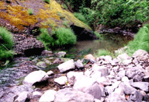
His Rancho San Antonio was the hinterland to San Francisco—40 leagues away by the shortest land route, within view but isolated by the wide expanse of often turbulent Bay. It had a background of  gigantic trees along the ridge; which sloped down through forests of live oaks and open fields of grass to the mud flats along the Bay, through it in their pristine glory in the 21 now forgotten creeks.


NURTURE SAN FRANCISCO  


Yet, those creeks and the lands they drained nurtured the City of San Francisco. 


They had their headwaters in dense groves of redwoods from which came the lumber that rebuilt San Francisco after fire had swept shacks and tents off the sand dunes.


They watered forests of oaks that enriched the land for grain production, lush grass on which cattle fattened. They teemed witli salmon and trout, and their outlets to the

Bay were over expansive beds of shellfish. Along their banks were deer and quail and rabbits above them huge flocks of ducks and geese blackened out the sun.


They fed and housed the pioneers struggling to create a city across the Bay. 


HAZARDOUS VENTURE


Exploration of the Contra Costa moved slowly in early days. It was effectively discouraged by the commandant of the Presidio of San Francisco who declared: "The country is almost unknown, the natives perverse, and the adventure too 

hazardous." 


Efforts of the padres from San Jose Mission to bring religion to the ''perverse natives," met such stubborn  resistance  lhat  armed guards had to accompany them for their protection. One of these was Sergeant Peralta, assigned in 1798

to command of the king's forces at the mission.


He conducted several expeditions into the Contra Costa and the great natural advantages he discovered there made him the first to covet its ownership. He could not forsee what the Gringo would do to those lands, would imdoubledly have been saddened by such foresight, but the fish, the game, the rich cattle feed all enticed him.


ESTATE DIVIDED


Retiring from service in 1820, he won a grant of Rancho San Antonio, and although he continued to live at San Jose, he considered it his most valued possession, an

estate which he divided among his four sons in 1842.


To Jose Domingo Peralta went the Northern scclion which has become Berkeley, and he built his hacienda on the banks of the Codornices. Vincente, who was to be first to feel the inroads of the Gringo, erected his home on Temescal, at what is now 5521 Vicente Street. Antonio Maria, awarded what is now East Oakland and Alameda,  placed his adobe on the creek which assumed his name, "Peralta," at what is now 2511 34th Avenue. Ygnacio built his home near San Leandro Creek and portions of it still stand as part of the Alta Mira Clubhouse.


Those were the days when the creeks received their first names. Some were later changed to correspond to street locations, or to take identity from early families. Others still remain today, retaining Indian or Spanish origin. But with meanings as nearly forgotten as the creeks themselves.


The Northernmost became Cerrito, from the "bald hill" at its mouth. Antonio and Jose Domingo feasted on quail eggs while hunting deer along one stream, and named it for the quail Codornices. Someone killed a mountain lion near

another and it became Arroyo del Leon, now Lion Creek. Sausal is from the Spanish word for the willow groves along its banks.


Euphonious Temescal had a most mundane origin. On its banks, near the present junction of Claremont, Avenue with Telegraph Avenue, was a large Indian village, with one solid structure of sturdy poles, made air-tight by thick slabs of mud. In it some 50 Indians danced around a roaring fire until nearly dead from heat and their exertions, when the door was opened and the exhausted patients of primitive

medicine allowed to dive into the cold waters of the creek. That was the Indian sweat house—the "temescal."


It probably helped to hasten the disappearance of the Indians. They lived a life of indolence and plenty, feeding on shellfish and leaving mounds of shells to testify to their gourmanderie, and on acorns. Their constant digging beneath the oak

trees for the latter is supposed to have earned the American nickname, "Diggers."


TRIBES DECIMATED


Their ferocity, which alarmed explorers, seems to have evaporated as the Spaniards gained ascendancy, cholera decimated the tribes in 1833, and pneumonia virtually wiped them out in the 50's.


The Spaniards superseded the Indans, but not for long. Within five years of the distribution of the Rancho San Antonio to Peralta's sons, the Gringo came.


First he took fish from the creeks, killed game animals slaughtered wildfowl. Then he built saw mills along the San Antonio estuary and felled the redwrnds. The discovery of gold gave sudden impetus by his operations, and before Don

Vicente realized what was happening, a city was growing and he was powerless to slop it.


(Second in a series of five articles.  Tomorrow--Maybe You Remember.)